|
|
Class: GASTROPODA
--- Taxon Tree: CAENOGASTROPODA [Subclass] - NEOGASTROPODA [Order] - CONOIDEA [Superfamily]
------ Family: TEREBRIDAE Mörch, 1852 (Sea)
------------ Genus: Terebra J.G. Bruguière, 1789
|
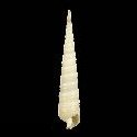
--------------- Species: Terebra funiculata R.B. Hinds, 1844 - ID: 2130000280
|
|
|
Philippines, Aliguay Island - 47 mm
|
|
|
|
|
|
|
synonyms: |
Terebra archimedis G.P. Deshayes, 1859
|
Terebra langfordi H.A. Pilsbry, 1921
| |
|
Terebra langfordi angustior H.A. Pilsbry, 1921
| |
|
Additional DB records: |
Olango Island (Philippines) - 57 mm
Olango Island (Philippines) - 54 mm
|
Calituban Island, Bohol - 50 mm
| | |
Palawan Island, Philippines - 49.7 mm
Solomon Is. - 47 mm
|
Hawaii - 45 mm
| | |
Mozambique - 45 mm
Mozambique - 41.5 mm
|
South China sea - 41 mm
| | |
Palawan,Philippnes - 40 mm
Tahiti - 40 mm
|
Mozambique - 36 mm
| | |
Olango Island (Philippines) - 36 mm
Bacongan Puerto,Palawan - 34 mm
|
Falevai Beach, Vava'u, Tonga - 29.5 mm
| | |
Marau Sound, Solomons - 27 mm
Oahu, Hawaii 1963 - 25 mm
|
Oahu Hawaii - 23.3 mm
| | |
Oahu Hawaii - 21.6 mm
hawaii - 21 mm
|
Mozambique - 35 mm
| | |
Bismarck Archipelago, Rabaul Harbor, New Britain Island
Cocos Keeling Islands, N. tip West Island
|
Guam, Along and in Tepungan Channel, Piti Bay
| | |
Hawaii, Honolulu, Honolulu Harbor, Oahu
Hawaii, Honolulu, Off Honolulu, Oahu
|
Honolulu County, Honolulu Harbor, Oahu
| | |
Honolulu County, Off Honolulu, Oahu
Indonesia, Flores Island
|
Indonesia, Irian Jaya, 1 mi. E by N Dauwi Island
| | |
Indonesia, Irian Jaya, S side Noekori Island
Indonesia, Pulau Rani Island, Schouten Islands
|
Irian Jaya, S side Noekori Island, E Padaido Islands
| | |
Japan, Wakayama Prefecture, Higashi-muro
Maldive Islands, Dunidu Island, N of Male (town)
|
Mariana Islands, Guam, Along and in Tepungan Channel
| | |
Mariana Islands, Guam, Asan Point
Marquesas Islands
|
Mascarene Islands, Jacotet Bay, Mauritius
| | |
New Caledonia, Bay, Baie de Touho
New Caledonia, Ile de Gatope, Voh
|
Palau, 1 1/4 mi. S. of Gorokottan Island
| | |
Palau, E lagoon off Melekeiok, E Babelthuap Island
Palau, Kayangel Lagoon
|
Palau, Namelakl Passage, East Babelthuap
| | |
Palau, Ngariungs & Ngarapalas Islands, Kayangel
Palau, North end of reef, Kayangel
|
Palau, reef west of Malakal Harbor
| | |
Palau, SW of Malakal Dock, Koror Island
Seychelles
|
Solomon Islands, Ataa, Malaita Island
| | |
|
|
|
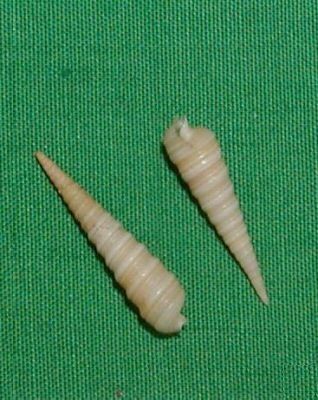
Image from Claudio Galli
Pokai Bay, Oahu, Hawaii. In sand pockets at 35 ft - 21 mm
|
|
|


