|
|
Class: GASTROPODA
--- Taxon Tree: CAENOGASTROPODA [Subclass] - CERITHIOIDEA [Superfamily]
------ Family: PLEUROCERIDAE P. Fischer, 1885 (Freshwater)
------------ Genus: Elimia H. Adams & A. Adams, 1854
|
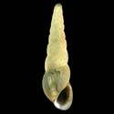
--------------- Species: Elimia acuta (C.S. Rafinesque, 1831) - ID: 1300150000
|
|
|
|
Additional DB records: |
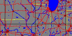
Arkansas, Berryville
Arkansas, Cotter
|
Arkansas, Hardy, Sharp County
| | |
Arkansas, Jasper
Arkansas, North Fork, Norfolk
|
Canada, Ontario, Hamilton
| | |
Canada, Ontario, Hamilton Bay
Canada/USA, Niagara
|
Canada/USA, Niagara Falls
| | |
Hawaii, Lahaina Maui
Illinois, Canton
|
Illinois, Lake Michigan
| | |
Illinois, Spoon River
Indiana, Wabash River, Wabash
|
Iowa, Davenport
| | |
Iowa, Iowa River, Iowa City
Iowa, Scott County, Davenport
|
Kansas, Fort Scott
| | |
Louisiana, Alexandria
Michigan, Lansing
|
Michigan, Mono Lake, Muskegon
| | |
Michigan, Swan Creek
Missouri, Jasper County
|
New York
| | |
New York, Conesus Lake
New York, Mohawk
|
New York, Mohawk River
| | |
New York, Niagara River
New York, Troy
|
Wisconsin, Afton
| | |
|
Wisconsin, Rock River
| |
|
|
------------------ Sub or form: Elimia acuta clavula I. Lea, 1868 - ID: 1302950160
|
|
|
|
Additional DB records: |
Alabama, Florence
Alabama, Madison County, Flint River Gurley
|
Alabama, Madison County, Flint River, Gurley
| | |
Alabama, Spout Spring, 2 1/2 mi. N of Woodville
Alabama, Tuscumbia
|
Michigan, Grand River, Grand Rapids
| | |
Tennessee
Tennessee, Marion County, Battle Creek its source, Dove
|
USA, Georgia
| | |
|
|
|
------------------ Sub or form: Elimia acuta hinkleyi C. Goodrich, 1921 - ID: 1302950010
|
|
|
|
Additional DB records: |
Illinois, Dubois
|
Illinois, Franklin County, Big Muddy River, Benton
| | |
|
|
------------------ Sub or form: Elimia acuta lewisi I. Lea, 1862 - ID: 1302950020
|
|
|
|
Additional DB records: |
Illinois River
Illinois, Havana
|
Illinois, Ilinois River, Canton
| | |
Illinois, Illinois River
Illinois, Illinois River Havana
|
Illinois, Illinois River, Peoria
| | |
Illinois, Spoon River
Iowa, Cedar River, Cedar Rapids
|
Michigan, Grand Rapids
| | |
|
Michigan, Saginaw
| |
|
|
|