|
|
Class: GASTROPODA
--- Taxon Tree: CAENOGASTROPODA [Subclass] - LITTORINIMORPHA [Order] - STROMBOIDEA [Superfamily]
------ Family: STROMBIDAE Rafinesque, 1815 (Sea)
------------ Genus: Canarium H.C.F. Schumacher, 1817
|
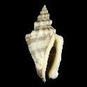
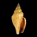
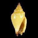
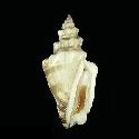
--------------- Species: Canarium urceus (C. Linnaeus, 1758) - ID: 1450000360
|
|
|
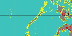
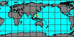
Philippines, Palawan Island - 53,6 mm
|
|
|
|
|
|
|
synonyms: |
Canarium anatellus P.L. Duclos in J.C. Chenu, 1844
|
Canarium reticulatus J.H.F. Link, 1807
| |
|
Canarium ustulatus H. Dodge, 1946
| |
|
Additional DB records: |
Mactan Island - 75.0 mm
Balicasag Island - 74 mm
|
SIASI ZAMBOANGA - 71 mm
| | |
Palawan Island, Philippines - 66 mm
Laminusa Is., Philippines - 63 mm
|
Sulu Sea, Philippines - 61 mm
| | |
Zamboanga Island, Philippines - 58 mm
Bohol - 57 mm
|
Bohol Philippines - 57 mm
| | |
Tablas Island - 56 mm
sindangan bay zambo norte - 56 mm
|
Cordova,Cebu,Philippines - 54 mm
| | |
Philippines - 53 mm
Bohol Philippines - 51 mm
|
Cantilan Surigao del Sur - 50 mm
| | |
Bohol, Phils. - 49 mm
Bohol Philippines - 48.5 mm
|
Olango Island, Cebu Philippines - 48 mm
| | |
Olango Island,Cebu - 46 mm
Central Philippines - 46 mm
|
Bohol, Phils. - 45 mm
| | |
Philippines - 45 mm
Bohol Philippines - 43.4 mm
|
NUCNUCAN ISLAND - 43 mm
| | |
bohol - 40 mm
Bohol Philippines - 38.4 mm
|
Bohol Philippines - 36.7 mm
| | |
Philippines - 35 mm
SIASI ZAMBOANGA - 33 mm
|
Balabac, Palawan - 25 mm
| | |
Olango island,Cebu - 21 mm
Bohol Philippines - 37 mm
|
Australia
| | |
Australia, Torres Straits
Japan
|
Mindoro Occidental, Lubang Island
| | |
Northern Territory
Northern Territory, Alawa, Darwin Coastal
|
Northern Territory, Litchfield, Darwin Coastal
| | |
Northern Territory, The Gardens, Darwin Coastal
Philippines
|
Philippines, Ticao
| | |
Shefa Province, Efate
Tasmania
|
Western Australia
| | |
Western Australia, Port Hedland, Pilbara
|
Western Australia, Roebourne, Pilbara
| | |
|
|
------------------ Sub or form: Canarium urceus incisum (W. Wood, 1828) - ID: 1450000365
|
|
|
Philippines, Masbate Island - 49 mm
|
|
|
|
|
|
|
Additional DB records: |
Davao Gulf (Philippines) - 44 mm
New Britain - 28 mm
|
Rabaul, Papua New Guinea - 28 mm
| | |
KERMADEC ISLANDS - 27,9 mm
Fiji Islands
|
Solomon Islands, Sun Malaita Id.
| | |
|
Western Australia, Augustus Island
| |
|
|
------------------ Sub or form: Canarium urceus orrae R.T. Abbott, 1960 - ID: 1450000370
|
|
|
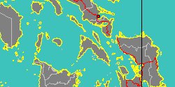
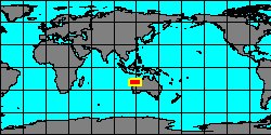
Australia, Port Hedland - 50,5 mm
|
|
|
|
|
|
|
Additional DB records: |
australia - 38 mm
Australia, WA, Cleaverville - 35 mm
|
Australia, Augustus Island
| | |
Australia, Legendre Island Dampier Arch.
Australia, Northern Territory, Shell & Channel Islands
|
Australia, western Australia, Broome
| | |
Australia, Western Australia, Exmouth Gulf
Australia, Western Australia, LaGrange Bay
|
Northern Territory
| | |
Northern Territory, East Arnhem
Northern Territory, East Arnhem - Bal, Arnhem Coast
|
Northern Territory, Tiwi Islands, Tiwi Cobourg
| | |
Northern Territory, West Arnhem, Tiwi Cobourg
Queensland
|
Queensland, Mornington, Gulf Plains
| | |
Western Australia
western Australia, Broome
|
Western Australia, Dampierland, Derby-West Kimberley
| | |
Western Australia, Exmouth Gulf
|
Western Australia, False Cape Creek, LaGrange Bay
| | |
|
|
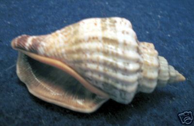
Image from Claudio Galli
Australia, Port Hedland - 40 mm
|
|
------------------ Sub or form: Canarium urceus ustulatus (H.C.F. Schumacher, 1817) - ID: 1450000375
|
|
|
|
Additional DB records: |
Thousand islands. - 68,8 mm
Thousand island - 65,5 mm
|
Palawan - 63 mm
| | |
Filipinas - 61 mm
Thousand Isl., Indonesia - 60 mm
|
Palawan - 60 mm
| | |
South China Sea - 57,6 mm
taiwan, Kaoshiung - 51 mm
|
Davao Gulf (Philippines) - 50 mm
| | |
South China Sea - 49,5 mm
Davao Gulf (Philippines) - 49 mm
|
Singapore - 43 mm
| | |
Philippines - 42 mm
Palawan, Philippines. - 41 mm
|
Negros, Philippines - 40 mm
| | |
Philippines - 36,5 mm
Sri Lanka - 30 mm
|
Thailand - 58 mm
| | |
|
Davao Gulf (Philippines) - 47 mm
| |
|
|
|