|
|
Class: GASTROPODA
--- Taxon Tree: HETEROBRANCHIA [Subclass] - PULMONATA [Infraclass] - STYLOMMATOPHORA [Order] - POLYGYROIDEA [Superfamily]
------ Family: POLYGYRIDAE Pilsbry, 1895 (Land)
--------- SubFamily: POLYGYRINAE
------------ Genus: Ashmunella H.A. Pilsbry & T.D.A. Cockerell, 1899
|
--------------- Species: Ashmunella proxima H.A. Pilsbry, 1905 - ID: 4461300135
|
|
|
|
Additional DB records: |
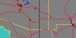
Arizona, Barfoot Park, Chiricahuas
Arizona, Bear Park, Chiricahua Mountains
|
Arizona, Below Indian Creek
| | |
Arizona, Big Emigrant Mountain
Arizona, Box Canon, of White Tail, Chiricahuas
|
Arizona, Cochise County, Rucker Canyon, upper camp
| | |
Arizona, Crooks Peak, Chiricahuas
Arizona, Ft. Bowie
|
Arizona, Hands Pass, head of Jhu, Chiricahuas
| | |
Arizona, Hands Pass, Pinery #1, Chiricahuas
Arizona, Hilltop Mine, Whitetail Canyon
|
Arizona, Limestone Mountain, Chiricahua Range
| | |
Arizona, Pinery Canyon, Chiricahua Mountains
Arizona, Quartzite Peak, Fort Bowie, Chiricahuas
|
Arizona, Rucker Canyon, Chiricahua Mountains, Cochise County
| | |
Arizona, Ruckers Peak, Chiricahua Range, Cochise County
Arizona, Saw Mill Canon, Chiricahua Mountains
|
Arizona, Shake Gulch, Chiricahua Range, Cochise County
| | |
|
Arizona, Station 14, Branch of White Tail, Chiricahuas
| |
|
|
------------------ Sub or form: Ashmunella proxima angulata H.A. Pilsbry, 1905 - ID: 4461900245
|
|
|
|
Additional DB records: |
Arizona, 1 to 2 mi. up S fork, Cave Creek (left side)
Arizona, 5 mi. Camp, Horreboe Creek, Chiricahuas
|
Arizona, Barfoot Park, Chiricahua Range, Cochise County
| | |
Arizona, Barfoot Park, Station 1a, Chiricahuas
Arizona, Cave Creek, Chiricahua Mountains
|
Arizona, Cave Creek, Station 12, Chiricahuas
| | |
Arizona, Cave Creek, Station 3, Chiricahuas
Arizona, Cave Creek, station 4, Chiricahuas
|
Arizona, Chiricahua Range, Cochise County
| | |
Arizona, Falls Cave Creek, Chiricahua Mountains
Arizona, Falls Fork of Cave Creek Canon
|
Arizona, Falls, Cave Creek, Chiricahua Mountains
| | |
Arizona, Horseshoe Canyon, Chiricahua Range, Cochise County
Arizona, Paradise, toward Cave Creek, Chiricahuas
|
Arizona, Raspberry Gulch, Chiricahua Range, Cochise County
| | |
Arizona, S. Fork Cave Creek
Arizona, S. fork Cave Creek, Chiricahua Mountains
|
Arizona, S. Fork, Cave Creek, Chiricahuas
| | |
Arizona, spring branch, head of Rucker, Chiricahuas
|
Arizona, under rocks, middle S fork, Cave Creek
| | |
|
|
------------------ Sub or form: Ashmunella proxima emigrans H.A. Pilsbry, 1910 - ID: 4461900253
|

|
|
USA
|
|
No Georeferenced data available
|
|
|
|
------------------ Sub or form: Ashmunella proxima fissidens H.A. Pilsbry, 1905 - ID: 4461900261
|
|
|
|
USA
|
|
No Georeferenced data available
|
|
|
|
------------------ Sub or form: Ashmunella proxima lepiderma H.A. Pilsbry & J.H. Ferriss, 1910 - ID: 4461900269
|
|
|
|
Additional DB records: |
Arizona, Chiricahua Range, Cochise County
Arizona, Hands Pass, head of Jhu, Chiricahuas
|
Arizona, NE side, White Tail Canon, Station 17, Chiricahuas
| | |
Arizona, White Tail Canon, Station 10, Chiricahuas
Arizona, White Tail Canon, Station 11, Chiricahuas
|
Arizona, White Tail Canon, Station 16, Chiricahuas
| | |
Arizona, White Tail Canon, Station 17, Chiricahuas
|
Arizona, White Tail Canyon, Chiricahua Range, Cochise County
| | |
|
|
|