|
|
Class: GASTROPODA
--- Taxon Tree: CAENOGASTROPODA [Subclass] - CERITHIOIDEA [Superfamily]
------ Family: PLEUROCERIDAE P. Fischer, 1885 (Freshwater)
------------ Genus: Elimia H. Adams & A. Adams, 1854
|
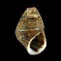
--------------- Species: Elimia caelatura (L.A. Reeve, 1860) - ID: 5140000012
|
|
|
------------------ Sub or form: Elimia caelatura excellens C. Goodrich, 1935 - ID: 1302950220
|
|
|
|
Additional DB records: |
|
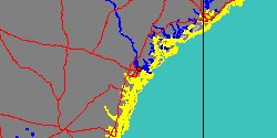
Alabama, Cherokee County, Little River, mouth
| |
|
|
------------------ Sub or form: Elimia caelatura georgiana I. Lea, 1862 - ID: 1300150080
|
|
|
|
|
------------------ Sub or form: Elimia caelatura infuscata I. Lea, 1862 - ID: 1300150085
|
|
|
|
Additional DB records: |
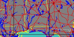
Alabama, Alabama Run, Montgomery River, Montgomery
Alabama, Big Wills Creek, above Gadsden, Etowah County
|
Alabama, Coosa River, Gadsden
| | |
Alabama, Little River Slough 1/2 mi. S. of Firestone
Alabama, Montgomery
|
USA, Georgia
| | |
USA, Georgia, Cedar Creek 12 mi. s.w. of Rome
USA, Georgia, Cedar Creek, 12 mi. s.w. of Rome
|
USA, Georgia, Cedartown
| | |
USA, Georgia, Etowah River, Cartersville
USA, Georgia, Floyd County
|
USA, Georgia, Oothkalooga Creek Calhohrn, Gordon County
| | |
USA, Georgia, Silver Creek, Rome
|
USA, Georgia, Stream 1 mi. SW of Carters, Gordon County
| | |
|
|
------------------ Sub or form: Elimia caelatura lecontiana (I. Lea, 1841) - ID: 1300150090
|
|
|
|
Additional DB records: |
Alabama, Calhoun County, outlet of Coldwater spring
Alabama, Calhoun County, Outlet, Coldwater Spring
|
USA, Georgia, Armuchee Creek, 6 mi. n.e. of Rome
| | |
USA, Georgia, Dalton
USA, Georgia, Floyd County
|
USA, Georgia, Walker County
| | |
|
|
|
------------------ Sub or form: Elimia caelatura luteocella I. Lea, 1868 - ID: 1300150095
|
|
|
|
Additional DB records: |
Alabama, Jackson County, Woodville
Tennessee
|
Tennessee, Clinch River
| | |
Tennessee, Knoxville
Tennessee, Whitfield County, Coahulla Creek, Cedar Ridge
|
USA, Georgia, Silver Creek Station, Floyd County
| | |
|
USA, Georgia, Whitfield County
| |
|
|
------------------ Sub or form: Elimia caelatura stearnsiana R.E. Call, 1886 - ID: 1300150100
|
|
|
|
Additional DB records: |
|
Alabama Calhoun - 11,3 mm
| |
|
|
|