WMSD - Worldwide mollusc species DB Bagni Liggia

Class: BIVALVIA
--- Taxon Tree: HETERODONTA [Subclass] - EUHETERODONTA [Infraclass] - IMPARIDENTIA [Superorder] - VENERIDA [Order] - VENEROIDEA [Superfamily]
------ Family: VENERIDAE Rafinesque, 1815 (Sea)
DB counters: Genus=143, Subgenus=43, Species=1623, Subspecies=84 ( 799 Species and 59 Subspecies have images)
DB counters include Fossil taxa: Species=789, Subspecies=18

« Previous 1 2 3 4 5 6 7 8 9 10 11 12 13 14 15 16 17 18 19 20 21 22 23 24 25 26 27 28 29 30  31 32 33 34 35 36 37 38 39 40 41 42 43 44 45 46 47 48 49 Next »

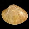
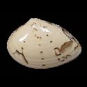
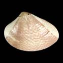
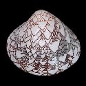
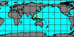
SubFamily: PITARINAE - Genus: Costacallista K.V.W. Palmer, 1927  (DB: 16 SP, 3 IMG)


7292001270

Costacallista
emmonsi

(FOSSIL)
Gardner, 1943 †

USA, North Carolina, Duplin

Map center:  N: 34° 53' 59'' W: 78° 5' 59''  - Grid: 5° - click to open

7292001204

Costacallista
gabrielensis

(FOSSIL)
Clark & J.W. Durham,
1946 †


Colombia, Bolivar

Map center:  N: 9° 41' 59'' W: 75° 5' 59''  - Grid: 5° - click to open

7292001205

Costacallista
hectori

(FOSSIL)
Finlay & J. Marwick,
1937 †


New Zealand, Canterbury, Waimate

Map center:  S: 44° 30' 0'' E: 170° 54' 0''  - Grid: 5° - click to open

7292001206

Costacallista
laevigata

(FOSSIL)
(J.B.P.A. Lamarck,
1806 †)


France, Paris Basin

Map center:  N: 48° 55' 10'' E: 2° 24' 46''  - Grid: 5° - click to open

7292001207

Costacallista
leiotera

(FOSSIL)
W.P. Woodring, 1982 †

Panama, Colón

Map center:  N: 9° 18' 0'' W: 79° 54' 0''  - Grid: 5° - click to open

7292001208

Costacallista
mancorensis

(FOSSIL)
A.A. Olsson, 1931 †

Peru

Map center:  S: 9° 42' 5'' W: 78° 22' 16''  - Grid: 5° - click to open

7292001271

Costacallista
pseudoumbonella

(FOSSIL)
E.W. Vredenburg, 1928 †

Pakistan, Baluchistan, Makran

Map center:  N: 25° 18' 0'' E: 63° 17' 59''  - Grid: 5° - click to open

7292001306

Costacallista
pseudoyawensis

(FOSSIL)
Iqbal, 1969 †

Pakistan, Sind, Hyderabad

Map center:  N: 26° 6' 0'' E: 67° 54' 0''  - Grid: 5° - click to open

6104400000

Costacallista
semperi

(J.B.P.A. Lamarck, 1818)

Australia, Dingo Beach
60,2 mm

Map center:  S: 20° 10' 11'' E: 148° 26' 28''  - Grid: 5° - click to open

7292001272

Costacallista
steinekei

(FOSSIL)
Clark & J.W. Durham,
1946 †


Colombia, Bolivar

Map center:  N: 9° 41' 59'' W: 75° 5' 59''  - Grid: 5° - click to open

7292001209

Costacallista
suberycinoides

(FOSSIL)
(G.P. Deshayes, 1825 †)

France, Paris Basin

Map center:  N: 48° 55' 10'' E: 2° 24' 46''  - Grid: 5° - click to open

7608000418

Costacallista
ugolnensis

(FOSSIL)
Devjatilova, 1981 †

Russia, Orlovka river

Map center:  N: 59° 42' 10'' E: 87° 15' 45''  - Grid: 5° - click to open

SubFamily: PITARINAE - Genus: Dollfusia A.E.M. Cossmann, 1886 †  (DB: 1 SP, 1 IMG)
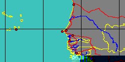
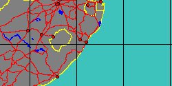
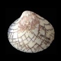
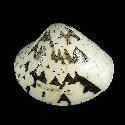
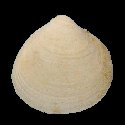

7292001210

Dollfusia
crassa

(FOSSIL)
A.E.M. Cossmann, 1886 †

France, Paris Basin

Map center:  N: 48° 55' 10'' E: 2° 24' 46''  - Grid: 5° - click to open

SubFamily: PITARINAE - Genus: Dosiniopsis T.A. Conrad, 1864 †  (DB: 6 SP, 3 IMG)


7292001211

Dosiniopsis
bellovacina

(FOSSIL)
(G.P. Deshayes, 1825 †)

France, Paris Basin

Map center:  N: 48° 55' 10'' E: 2° 24' 46''  - Grid: 5° - click to open

7292001212

Dosiniopsis
fallax

(FOSSIL)
(G.P. Deshayes, 1857 †)

France, Paris Basin

Map center:  N: 48° 55' 10'' E: 2° 24' 46''  - Grid: 5° - click to open

7292001346

Dosiniopsis
lenticularis

(FOSSIL)
(B. Rogers, 1838 †)

USA, Virginia, King George

Map center:  N: 38° 17' 59'' W: 77° 17' 59''  - Grid: 5° - click to open

7608000546

Dosiniopsis
nebrascensis

(FOSSIL)
F.B. Meek & Hayden,
1876 †


No Georeferenced data available

7292001213

Dosiniopsis
pseudoorbicularis

(FOSSIL)
Tremlett, 1953 †

France, Paris Basin

Map center:  N: 48° 55' 10'' E: 2° 24' 46''  - Grid: 5° - click to open

7292001214

Dosiniopsis
stewartvillensis

(FOSSIL)
Clark & Woodford, 1927 †

USA, California, Contra Costa

Map center:  N: 37° 53' 59'' W: 121° 54' 0''  - Grid: 5° - click to open

SubFamily: PITARINAE - Genus: Larma Stephenson, 1953 †  (DB: 1 SP, 0 IMG)
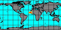
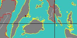
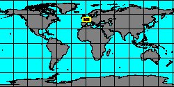

7608000483

Larma
taffi

(FOSSIL)
(Cragin 1893) †


No Georeferenced data available

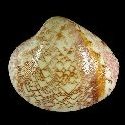
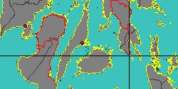
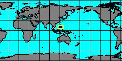
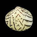
SubFamily: PITARINAE - Genus: Lepidocardia W.H. Dall, 1902  (DB: 1 SP, 2 IMG)


6107501072

Lepidocardia
floridella

(J.E. Gray, 1838)

Senegal, Dakar
22 mm

Map center:  N: 14° 41' 42'' W: 17° 26' 38''  - Grid: 5° - click to open

6107502533

Lepidocardia
floridella
africana

(J.K. Megerle Von Mühlfeld in R.A. Philippi, 1843)

South Africa, Durban
9,6 mm

Map center:  S: 29° 48' 59'' E: 30° 58' 40''  - Grid: 5° - click to open

SubFamily: PITARINAE - Genus: Lioconcha O.A.L. Mörch, 1853  (syn: Sulcilioconcha - DB: 25 SP, 16 IMG)


6104604010

Lioconcha
annettae

K.L. Lamprell
& T. Whitehead, 1990


New Caledonia
35 mm

Map center:  S: 21° 15' 0'' E: 165° 18' 0''  - Grid: 5° - click to open

7194000065

Lioconcha
arabaya

S.E.T. Van der Meij, R.G. Moolenbeek
& H. Dekker, 2010


Arabian Gulf

Map center:  N: 27° 3' 2'' E: 51° 44' 49''  - Grid: 5° - click to open

6104600000

Lioconcha
berthaulti

K.L. Lamprell
& J.M. Healy, 2002


Philippines, Olango Island
25,8 mm

Map center:  N: 10° 15' 52'' E: 124° 3' 23''  - Grid: 5° - click to open

6107502635

Lioconcha
caledonensis

M.E. Harte
& K.L. Lamprell, 1999


No Georeferenced data available

6104600005

Lioconcha
castrensis

(C. Linnaeus, 1758)

Philippines, Calituban Island
50 mm

Map center:  N: 10° 10' 11'' E: 124° 22' 55''  - Grid: 5° - click to open

6104600010

Lioconcha
fastigiata

(G.B. II Sowerby, 1851)

Philippines, Palawan Island
20 mm

Map center:  N: 9° 36' 25'' E: 118° 29' 27''  - Grid: 5° - click to open

6107502625

Lioconcha
fastigiata
pseudofastigiata

K.L. Lamprell
& J.M. Healy, 2002


Philippines
30,4 mm

Map center:  N: 12° 48' 17'' E: 121° 45' 24''  - Grid: 5° - click to open

6107502591

Lioconcha
gordoni

(E.A. Smith, 1885)


No Georeferenced data available

7194000066

Lioconcha
harteae

M. Huber, 2010


No Georeferenced data available

6104604015

Lioconcha
hieroglyphica

(T.A. Conrad, 1837)

Philippines, Bantayan Island
40,2 mm

Map center:  N: 11° 12' 18'' E: 123° 44' 34''  - Grid: 5° - click to open

7242000039

Lioconcha
kovalisi

R. De Prins, 2013


No Georeferenced data available

7194000068

Lioconcha
lamprelli

R.G. Moolenbeek, H. Dekker
& S.E.T. Van der Meij, 2008


No Georeferenced data available

6104604020

Lioconcha
macaulayi

K.L. Lamprell
& J.M. Healy, 2002


New Caledonia

Map center:  S: 21° 15' 0'' E: 165° 18' 0''  - Grid: 5° - click to open


« Previous 1 2 3 4 5 6 7 8 9 10 11 12 13 14 15 16 17 18 19 20 21 22 23 24 25 26 27 28 29 30  31 32 33 34 35 36 37 38 39 40 41 42 43 44 45 46 47 48 49 Next »

Author: Claudio Galli - last updated: 27/ago/2017