|
|
Class: BIVALVIA
--- Taxon Tree: PALAEOHETERODONTA [Subclass] - UNIONIDA [Order] - UNIONOIDEA [Superfamily]
------ Family: UNIONIDAE Rafinesque, 1820 (Freshwater)
--------- SubFamily: AMBLEMINAE
------------ Genus: Lampsilis C.S. Rafinesque, 1820
|
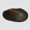
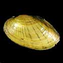
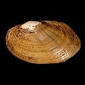
--------------- Species: Lampsilis radiata (J.F. Gmelin, 1791) - ID: 5537900100
|
|
|
|
Additional DB records: |
Canada, Ontario, Carlton County
Canada, Ontario, Hastings County
|
Canada, Ontario, Norfolk County
| | |
Connecticut, West Granby
Delaware, Sussex County, Seaford
|
Indiana, Shelby County, Flat Rock
| | |
Maryland, Kent County
Michigan, Carp Lake
|
Michigan, Detroit
| | |
New Jersey, Trenton
New York
|
New York, Chautauqua Lake
| | |
New York, Chemung River
New York, Essex County, Long Pond
|
New York, Genesee River
| | |
New York, Hudson River
New York, Mohawk and Buffalo
|
New York, Onondaga Lake
| | |
New York, Saint Lawrence
New York, Saratoga Lake
|
New York, Schuylers Lake
| | |
New York, Seneca Lake
Ohio, Port Clinton
|
Pennsylvania
| | |
Pennsylvania, Lancaster County
Pennsylvania, Schuylkill River
|
Thousand Islands
| | |
USA, Connecticut River
Virginia
|
Virginia, James River
| | |
|
Virginia, Orange
| |
|
|
------------------ Sub or form: Lampsilis radiata conspicua I. Lea, 1872 - ID: 5537900105
|
|
|
|
Additional DB records: |
Arkansas, Montgomery County, Ouachita River
North Carolina, Montgomery County, Okeewemee, Densons Creek
|
South Carolina, Barnwell County
| | |
USA, Georgia
USA, Georgia, Altamaha River
|
USA, Georgia, Jefferson Davis County
| | |
USA, Georgia, Ocmulgee River, 1 mi S of Lumber City
USA, Georgia, Ocmulgee River, Ben Hill County
|
USA, Georgia, Savannah River
| | |
USA, Georgia, Savannah River, Mile 157
USA, Georgia, Savannah River, Ring Jaw Point
|
USA, Georgia, Tattnall County, Ohoopee River
| | |
USA, Georgia, Telfair County
USA, Georgia, Wayne County
|
USA, Georgia/South Carolina, Savannah River
| | |
|
Virginia, Brunswick County, Rawlings, Nottoway River
| |
|
|
------------------ Sub or form: Lampsilis radiata luteola (J.B.P.A. Lamarck, 1819) - ID: 5537900110
|
|
|
|
Additional DB records: |
Netherlands Antilles, Playa Abau, Curacao Island
|
New York, Cortland County
| | |
|
|
------------------ Sub or form: Lampsilis radiata siliquoidea D.W. Barnes, 1823 - ID: 5537900140
|
|
|
|
synonyms: |
|
Lampsilis siliquoidea D.W. Barnes, 1823
| |
|
Additional DB records: |
Blue River
Canada
|
Illinois, Litabfield
| | |
Illinois, Ringwood
Indiana, Blue River
|
Indiana, Wabash
| | |
Indiana, White River
Iowa, Davenport
|
Iowa, Des Moines
| | |
Iowa, Iowa City
Kansas, Soldier Creek
|
Michigan
| | |
Michigan, Douglas Lake
Michigan, Reed Lake
|
Michigan, Saginaw Bay
| | |
Minnesota, Lake Blum
New York
|
New York, Buffalo
| | |
New York, Erie Canal
New York, Lake Seneca
|
New York, Oneida Lake
| | |
Ohio
Ohio River
|
Ohio, Big Cedar Creek
| | |
Ohio, Cleveland
Ohio, mahoning River
|
Ohio, Ohio Canal
| | |
Wisconsin, Koshkonong
Wisconsin, Lake Ellen
|
Wisconsin, Milwaukee
| | |
|
|
|
|